This map shows Ancient Roman roads as a subway network
Ever wondered how Italy's Roman roads would look reimagined as a subway map? Well, now you have an answer.
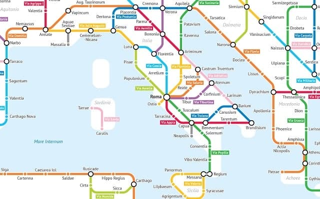
The roads that connected key cities of the vast empire have been reimagined as Metro lines in the map by Sasha Trubetskoy, a statistics student at the University of Chicago.
On the map, ancient cities become subway stops, connected by well-known road routes such as the Via Appia which linked Rome with Brindisi, as well as lesser-known roads.
"I've always had an interest in Ancient Rome, starting from when I read Asterix as a little kid," the designer told The Local.
-
This map shows where to find the best desserts in Italy
-
Map shows how an Italian city inspired Lord of the Rings
-
Fifteen maps that tell the story of Italy
The full version of the map, which covers the entire empire, is shown below - see a bigger version here.
.png)
"I had the spontaneous idea to model the ancient road network in a modern style. I was motivated by a desire to produce a high-quality transit-style map, unlike all the poorly designed maps I've been seeing online," Trubetskoy explained.
Trubetskoy used old maps of Ancient Rome and based his work on the empire at around 125 AD, though he also outlined the 'creative liberties' he took in his design, including inventing names for roads which don't have a known name and leaving out smaller cities to avoid overcrowding the map.
He also shared an alternative version of the Roman Roads map on Twitter, inspired by London's Underground network.
This was V2 of the Roman Roads tube map. More similar to London tube map. Several reasons I went with V3 (the one I published) instead: pic.twitter.com/VeLMxmbVFU
— Sasha Trubetskoy (@MyBoyTrubetskoy) August 31, 2017
READ ALSO: Mythbusting Ancient Rome - did all roads actually lead there?
Image: Wikimedia Commons
Comments
See Also
The roads that connected key cities of the vast empire have been reimagined as Metro lines in the map by Sasha Trubetskoy, a statistics student at the University of Chicago.
On the map, ancient cities become subway stops, connected by well-known road routes such as the Via Appia which linked Rome with Brindisi, as well as lesser-known roads.
"I've always had an interest in Ancient Rome, starting from when I read Asterix as a little kid," the designer told The Local.
- This map shows where to find the best desserts in Italy
- Map shows how an Italian city inspired Lord of the Rings
- Fifteen maps that tell the story of Italy
The full version of the map, which covers the entire empire, is shown below - see a bigger version here.
"I had the spontaneous idea to model the ancient road network in a modern style. I was motivated by a desire to produce a high-quality transit-style map, unlike all the poorly designed maps I've been seeing online," Trubetskoy explained.
Trubetskoy used old maps of Ancient Rome and based his work on the empire at around 125 AD, though he also outlined the 'creative liberties' he took in his design, including inventing names for roads which don't have a known name and leaving out smaller cities to avoid overcrowding the map.
He also shared an alternative version of the Roman Roads map on Twitter, inspired by London's Underground network.
This was V2 of the Roman Roads tube map. More similar to London tube map. Several reasons I went with V3 (the one I published) instead: pic.twitter.com/VeLMxmbVFU
— Sasha Trubetskoy (@MyBoyTrubetskoy) August 31, 2017
READ ALSO: Mythbusting Ancient Rome - did all roads actually lead there?
Image: Wikimedia Commons
Join the conversation in our comments section below. Share your own views and experience and if you have a question or suggestion for our journalists then email us at [email protected].
Please keep comments civil, constructive and on topic – and make sure to read our terms of use before getting involved.
Please log in here to leave a comment.